Mobile Magic: BaseMap’s Ultimate Hunt Planner App
Last updated: March 23, 2026 · Originally published: August 20, 2024
Quick Answer
BaseMap is a hunting GPS and mapping app that shows your exact location — even with no cell service — against private property boundaries, public land, roads and trails. It displays nationwide parcel lines with owner names, offers unlimited offline map downloads, and includes wind and weather planning (HuntWind) plus point-and-go navigation, making it a popular tool for scouting and staying legal on the hunt.
BaseMap hunting app: quick facts
What does the BaseMap app do?
It is a hunting GPS app that maps public and private land, shows property boundaries and owner names nationwide, and tracks your location offline.
Does BaseMap work without cell service?
Yes — it offers unlimited offline map caching, so you can navigate and track your position off-grid.
Can BaseMap show property lines and owners?
Yes — it displays nationwide private parcel boundaries with owner names, parcel size and access points to help you hunt legally.
Does BaseMap help plan around the wind?
Yes — its HuntWind and Weather Center show wind forecasts and scent-drift direction so you can pick the right stand and time.
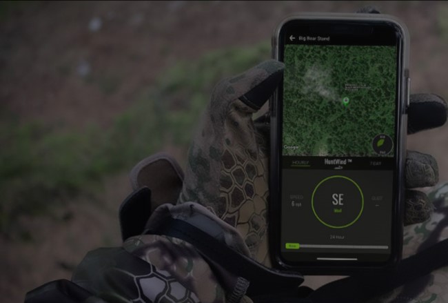
It’s like having Daniel Boone, a lawyer, and a soothsayer in your pocket!
As an older hunter, I’ll always tout the importance of knowing how to use a compass and topo map to navigate, because I can’t quite trust my cellphone to have a signal wherever I am. That said, the new hunting tools you whippersnappers have dreamed up are absolutely fantastic. The latest one I can’t wait to try is BaseMap’s HuntPlanner.
BaseMap’s HuntPlanner is changing the game for hunters, offering a suite of innovative features that cater specifically to the needs of modern hunters. With an emphasis on ease of use, advanced mapping technology, and personalized hunting tools, BaseMap is the go-to app for hunting planning and execution. In addition to its robust hunting features, BaseMap’s Pro Advantage and Pro Ultimate Subscriptions include Global Rescue services, providing hunters with 24/7 medical advisory and rescue services in case of emergencies, and giving you peace of mind when exploring on/off grid.
Key Benefits of the Full-Featured HuntPlanner:
- Ultimate Mobile Experience: The only HuntPlanner designed specifically for mobile devices, enabling hunt planning anywhere anytime.
- Integrated Mapping Technology: The only fully integrated hunt planner on the market. Access and view every map layer while exploring hunts: view wildfires, logging cuts, access points, wilderness areas and any of BaseMap’s 800+ layers while using the hunt planner.
- Unit Filtering: Quickly identify the best hunting opportunities based on state, species, hunt type, residency, weapon, harvest success, public land availability, trophy quality, and more.
- Draw Odds: Make informed decisions with access to draw odds at any point level, know the minimum points required, and viewpoint trends over time.
- Harvest Success: Focus on hunts with the highest success rates by viewing historical harvest trends, days hunted, and harvest counts.
- Unit Insights: Gain detailed information on any unit, including trophy quality, public land percentage, unit scores, and access points.
Basic HuntPlanner Capabilities:
Allows for filtering for state, species and hunt type, which allows for viewing of hunting units, unit scores, trophy potential, percentage of public ground.
In concert with this technology release, BaseMap also announced new, tailored pricing plans that allow consumers to utilize the BaseMap tools that best fit their needs.
Pricing Tiers:
BaseMap Pro – $39.99/year
- Nationwide land ownership maps and Basic HuntPlanner tools – all 50 states
BaseMap Pro Advantage – $69.99/year
- Nationwide land ownership maps, Basic HuntPlanner tools and field rescue by Global Rescue – all 50 states
BaseMap Pro Ultimate – $99.99/year
- Nationwide land ownership maps, Full Featured HuntPlanner tools and field rescue by Global Rescue – all 50 states
How to access the HuntPlanner:
1. Get started by downloading the BaseMap app from the App Store or Google Play.
2. Subscribe: Choose the BaseMap Pro Ultimate Subscription.
3. HuntPlanner: Can be found first in the tool bar at the bottom of the app.
Reader Favorites
Field-to-table reference desk
From tag to table — official season dates for all 50 states, plus safe doneness temps for your harvest.
| Species | Archery | Firearm |
|---|---|---|
| Deer | Sep–Oct | Nov |
| Elk | Sep | Oct–Nov |
| Turkey | — | Apr–May |
All 50 state wildlife agencies, plus how seasons, tags and licenses work.
Find your state → Network| Doneness | Target |
|---|---|
| Rare | 125–130°F |
| Medium-rare | 130–135°F |
| Well-done | 160°F+ |
Safe pull temps for venison and steak, from Popular BBQ.
View full chart →